Here you have an introduction to the model.
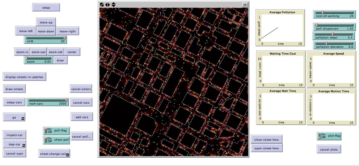
The image below is a static picture of the simulator (GIS applets still do not work in remote), but you can find the code
here and run it in your computer (NetLogo 4.1.3 suggested).
powered by NetLogo
view/download model file: traffic_and_pollution_in_torino.nlogo
This model uses GIS extension in order to simulate traffic in the city of Torino (Italy) and it shows how traffic conditions influence pollution in the city; in addition it is possible to approximate the amount of money lost due to traffic delays.
Patches not intersecting the GIS represent streets and, of course, turtles (cars) can only move on these patches. Turtles are expected to "drive" on the right, speed is represented by the number of patches they go forward and it decreases if there are any other turtles ahead.
Each patch has an indicator of its pollution levels depending on the number of cars on it and pollution diffuses to other patches as time passes.
Each turtle shows speed, waiting time and motion time.
First of all setup allows to import the GIS, then it is possible to move on the map and choose different areas of the city of Torino; there is a zoom utility but it is recommended to set zoom between 0.05 and 0.08 before going on.
Display-streets-in-patches (a bit slow) makes the distinction between streets and buildings, while draw-streets draws roadways. Notice that it is possible to open or close parts of a street using close-street-here and open-street-here.
Setup-cars creates the selected number of turtles and Go makes them move.
Two buttons allow to follow one of the turtles and to change color to its path.
Two switches allow to consider pollution and to show its concentration on the map; notice that original colors can be brought back using cancel-colors.
Change-street-color makes streets fade at car passage.
It is advisable to follow this order in pressing buttons:
setup / display-streets-in-patches / draw-streets / setup-cars / go.
Sliders:
cost-of-working represents the average cost of an hour of work (in euros or dollars)
poll-dispersion, if positioned at 1.00 no pollution is dissipated, if positioned at 2.00 50% of pollution disappears
The pollution growth caused by cars is represented by a normal probability distribution with parameters pollution-mean and deviation-mean
SantaFeStreets model -- http://backspaces.net/wiki/NetLogo_Bag_of_Tricks#NetLogo_GIS
Traffic Grid model -- Netlogo Library
;;;;;;;;;;;;; LUCA ALASIO - Scuola di Studi Superiori dell'Università di Torino ;;;;;;;;;;;;;;;;;;;


extensions [gis]

globals [
         torino            ;; GIS dataset
         streets           ;; patches representing streets
         center-x          ;;
         center-y          ;; center of the map
         roads             ;; patches representing roadways
         mean-poll         ;; average pollution indicator
         mean-wait-time    ;; average time turtles stay at rest
         mean-motion-time  ;; average time turtles stay in motion
         mean-speed        ;; turtles'speed indicator
         total-cost        ;; cost of time spent waiting
         ]

patches-own
[
  street?       ;; true if the patch is part of a street.
  color-p       ;; indicates right hand traffic
  turtles-num   ;; number of turtles on the patch
  pollution     ;; amount of pollution on the patch
]

turtles-own
[
  speed         ;; the speed of the turtle
  wait-time     ;; the amount of time since the last time a turtle has moved
  motion-time   ;; the amount of time with positive speed
  color-c       ;; indicates right hand traffic

]


;; WORLD ;;;;;;;;;;;;;;;;;;;;;;;;;;;;;;;;;;;;;;;;;;;;;;;;;;;;;;;;;;;;;;;;;;;;;


to setup
  clear-all
  ask patches [set pcolor white]
  set torino gis:load-dataset "torino/file.shp"
  draw
end

to draw
  clear-drawing
  setup-world-envelope
  gis:set-drawing-color gray + 1  gis:draw torino 1
  end

to setup-world-envelope
  gis:set-world-envelope gis:envelope-of torino
  let world gis:world-envelope
  let x0 (item 0 world + item 1 world) / 2  + center-x; center
  let y0 (item 2 world + item 3 world) / 2  + center-y
  let W0 zoom * (item 1 world - item 0 world) / 2 ; half-widths
  let H0 zoom * (item 3 world - item 2 world) / 2
  set world (list (x0 - W0) (x0 + W0) (y0 - H0) (y0 + H0))
  gis:set-world-envelope world
end

to center-here
  while [not mouse-down?] [wait .01]
  set center-x center-x + (mouse-xcor * gis-patch-size)
  set center-y center-y + (mouse-ycor * gis-patch-size)
  draw
end

to-report gis-patch-size ;; note: assume width & height same
  let world gis:world-envelope
  report (item 1 world - item 0 world) / (max-pxcor - min-pxcor)
end

to zoom-in  set zoom max list .01 precision (zoom - .1) 2
  draw
end

to zoom-out set zoom min list 1.2 precision (zoom + .1) 2
  draw
end

to zoom-std
  set zoom 0.05
  draw
end

to move-right
  set center-x center-x + shift * gis-patch-size
  draw
end

to move-left
  set center-x center-x - shift * gis-patch-size
  draw
end

to move-up
  set center-y center-y + shift * gis-patch-size
  draw
end

to move-down
  set center-y center-y - shift * gis-patch-size
  draw
end

to display-streets-in-patches
  ask patches [ set pcolor black
                set street? true ]
  ask patches gis:intersecting torino
  [ set pcolor white
    set street? false ]

  set streets patches with  [street? = true]

end


;; STREETS ;;;;;;;;;;;;;;;;;;;;;;;;;;;;;;;;;;;;;;;;;;;;;;;;;;;;;;;;;;;;;;;;;;;;;;;;;;;;;


to draw-streets-E
ask streets
[ if ( [pcolor] of patch-at 1 0 = white and
       [pcolor] of patch-at 1 1 = white and
       [pcolor] of patch-at 1 -1 = white
    )
      [set pcolor red]
]
end

to draw-streets-W
ask streets
[ if ( [pcolor] of patch-at -1 0 = white and
       [pcolor] of patch-at -1 1 = white and
       [pcolor] of patch-at -1 -1 = white
    )
      [set pcolor blue]
]
end

to draw-streets-N
ask streets
[ if ( [pcolor] of patch-at 0 1 = white and
       [pcolor] of patch-at 1 1 = white and
       [pcolor] of patch-at -1 1 = white
    )
      [set pcolor yellow
  ]
]
end

to draw-streets-S
ask streets
[ if ( [pcolor] of patch-at 0 -1 = white and
       [pcolor] of patch-at -1 -1 = white and
       [pcolor] of patch-at 1 -1 = white
    )
      [set pcolor green]
]
end

to draw-streets  ;; set a different color in order to make roadways recognisable
  draw-streets-N
  draw-streets-S
  draw-streets-E
  draw-streets-W

  set roads streets with [ pcolor != black ]
  ask streets [set color-p pcolor]
end

to cancel-colors
  ask patches
   [ if street? = false [set pcolor white] ]
  ask streets
   [set pcolor black]
end


;; TURTLES ;;;;;;;;;;;;;;;;;;;;;;;;;;;;;;;;;;;;;;;;;;;;;;;;;;;;;;;;;;;;;;;


to setup-cars
  set-default-shape turtles "car"
  create-turtles num-cars

  put-on-street
  ask turtles [set speed 1]
end

to put-on-street
  ask turtles [move-to  one-of roads]

end


to go

 if poll-flag = true
  [
  ask streets [set turtles-num count turtles-on self]
  evaluate-pollution
  ]

 if plot-flag = true
  [ do-plots ]

 ask turtles
 [
    if color-p != black
    [set color-c color-p]

    let turtles-ahead turtles in-cone 2 45

     ifelse any? turtles-ahead
         [ slow
           rt 7 + random-float 3 ]
         [speed-up]

     if ([pcolor] of patch-ahead 1 != white) and ([street?] of patch-ahead 1 = true)
            [fd 1]

    ifelse ([pcolor] of patch-ahead 1 = white) or ([street?] of patch-ahead 1 = false)
    [ lt 30 ]
       [
          ifelse (color-c = [color-p] of patch-at 1 0)
                  or
                 (color-c = [color-p] of patch-at 1 1)
                 or
                 (color-c = color-p)

           [ speed-up
             if ([pcolor] of patch-ahead speed != white) and ([street?] of patch-ahead speed = true)
             [fd speed]
           ]
           [ rt -15 + random-float 30
             speed-up
             if ([pcolor] of patch-ahead speed != white) and ([street?] of patch-ahead speed = true)
             [fd speed]
            ]
        ]

     ifelse speed = 0
     [ set wait-time wait-time + 1
       set motion-time 0]
     [ set wait-time 0
       set motion-time motion-time + 1]


 ]
tick
end

to slow
  if (speed > 0)
  [set speed speed - 1]
end

to speed-up
  let turtles-ahead turtles-at 0 1
  if ([pcolor] of patch-ahead 2 != white) and (not any? turtles-ahead)
   [ set speed speed + 1]
end

to cancel-cars
  clear-turtles
    set total-cost 0
end

to add-cars
  set-default-shape turtles "car"
  create-turtles num-cars
  ask turtles [set speed 1
               move-to one-of streets]
end


;; POLUTION AND PLOTS ;;;;;;;;;;;;;;;;;;;;;;;;;;;;;;;;;;;;;;;;;;;;;;;;;;;;;;;;;;;;;;;;;;;;


to evaluate-pollution

  ask streets
  [
    if turtles-num != 0
    [
      set pollution pollution  + abs ( random-normal (turtles-num * pollution-mean) (turtles-num * pollution-deviation) )
    ]

  ]

  diffuse pollution 0.7

  ask patches
  [
    set pollution pollution / poll-dispersion
  ]

  if show-poll = true
  [show-pollution]


  set mean-poll mean [pollution] of patches

  set-current-plot "Average Pollution"
  set-current-plot-pen "mean-poll"
  plot mean-poll

end

to do-plots

  set mean-wait-time mean [wait-time] of turtles

  set-current-plot "Average Wait Time"
  set-current-plot-pen "mean-wait-time"
  plot mean-wait-time

  set total-cost total-cost + (count turtles with [speed = 0]) * (cost-of-working / 3600)

  set-current-plot "Waiting Time Cost"
  set-current-plot-pen "total-cost"
  plot total-cost

  set mean-motion-time mean [motion-time] of turtles

  set-current-plot "Average Motion Time"
  set-current-plot-pen "mean-motion-time"
  plot mean-motion-time

  set mean-speed mean [speed] of turtles

  set-current-plot "Average Speed"
  set-current-plot-pen "mean-speed"
  plot mean-speed

end

to show-pollution
  ask patches
  [
    if (pollution >= 0)
    [set pcolor 10 + pollution * 2 / 3]
  ]
end


to cancel-plots
  clear-all-plots
end

to cancel-pollution
  ask patches
  [set pollution 0]
end


;; OBSERVATION ;;;;;;;;;;;;;;;;;;;;;;;;;;;;;;;;;;;;;;;;;;;;;;;;;;;;;;;;;;;;;;;;;;


to inspect-car
  inspect turtle 1

   ask turtle 1
   [set pcolor cyan]
end

to map-car
   ask turtle 1
   [set pcolor cyan]
end

to cancel-cyan
ask streets
[if pcolor = cyan
  [set pcolor black]
]
end

to street-change-color
  ask turtles
  [ if pcolor < 9
    [set pcolor (pcolor + 0.2)]
  ]
end


to close-street-here
  while [not mouse-down?] [wait .01]
  let posx mouse-xcor
  let posy mouse-ycor
   ask patches
  [if distance patch posx posy < 2
    [set pcolor white] ]
end

to open-street-here
  while [not mouse-down?] [wait .01]
  let posx mouse-xcor
  let posy mouse-ycor
  ask patches
  [if distance patch posx posy < 2
    [set pcolor black] ]
end


;;;;;;;;;;;;; LUCA ALASIO - Scuola di Studi Superiori dell'Università di Torino ;;;;;;;;;;;;;;;;;;;